Abandoned Gas - The Whistle Pig - South Fork, CO (St. Elmo, 4 Corners and more!)
September 2016, Laura and I were going to celebrate our first year of Civil Unionifying (don’t say the M word!), and were looking for somewhere to go for a few days. Nothing extravagant, just a get away from Denver and see something new.
My choice destination was the abandoned Whistle Pig convenience store, in South Fork, Colorado!

Because that is the CUTEST little logo!
She agreed that I could go hang out and take pictures in South Fork, but it had to be more than that. For some reason, she didn’t think an abandoned gas station was the best vacation for our first Civils Unioned anniversary.
Okay, it didn’t happen that way...

In reality, when the idea of where to go was first mentioned, I already had a proposal ready. A few months earlier, I had worked on the Summer/Fall 2016 Pagosa Magazine, at my stupid day (night) job. We printed a lot of regional Colorado travel magazines, during my years there. I usually didn’t pay a whole lot of attention to them, but something about Pagosa Springs and the surrounding area, struck a chord with me.
After my brief sales pitch, she liked the idea. I remembered the magazine and grabbed a copy from the file room the next night, and brought it home for Laura to look through. Before long, she had our 4 days and three nights planned out, including a place to stay.
Well, that was easy!
*******
We left Englewood on highway 285, westbound. The main east/west route known as Hampden Avenue through town, also crosses the Rocky Mountain foothills, and takes you deep into the mountains. To get where we're going is a good amount of Highway 285, before going on roads I've never travelled on to finish the journey.

Sinclair pit-stop in Fairplay, Colorado. Needed drinks, snacks, restrooms (not using the random toilet sitting next to the north side of the building) and cigarettes pad our time a bit. While Laura was inside the D&S Convenience Store, looking at whatever she was looking at, I snapped a few photos of the Sinclair dinosaur mascot. Confined to a den of gravel, fenced in by rocks he or she should easily be able escape.
I did try a slice of the Hunt Brothers Pizza. Not bad, but Mike makes a greasy, sloppy pepperoni.

Smooth sailing still southwest on 285, until we were outside Buena Vista. Where traffic backed up outside of town, awaiting their chance to turn north or south, a mile or so up the road. We were going south, but it took us over 30 minutes to even make that turn. Construction on a small bridge appeared to be equally responsible as the ill-timed traffic light.

I took my first abandoned gas station picture of the trip, waiting for that light to turn green. Still several cycles away at this point. Putting in a little effort on Google Maps, I see the building has been renovated into a coffee shop. The Station 24 Cafe appears to have opened in 2022.
About 15 miles south of Buena Vista, traffic backed up again. This time due to the town of Poncha Springs. Highway 285 south merges into Highway 50 going east. We''ll come back to Poncha Springs on the way home. For now it's onto the town of Saguache! (Pronounced: se-WATCH.) I was told this by Brad of My Buddie fame. He also told me of a cool abandoned theater in town, that I didn’t see because I didn’t know to look for it.

We didn't need gas here, but Laura needed a few things so I went inside to see what they had. Given its size, I figured it was more of a general store for this town of less than 600. They had what we needed, and it was well stocked with just what you would need in a small town general store. They also let me use the restroom. Which is something that is near impossible to get now, according to reviews on the Googles.

They even had a pay phone on the wall!

Across the street is a building(s) I loved. The Tire & Lumber Mart is something I wish I would have gotten a few more and better pictures of. Looks like something a little kid would build out of Legos. Just a bunch of of mis-matched individual structures... Classic!

Getting ready to leave the gas station/general store, we saw this deer eating apples off the tree in the lot next door. Now you just stay there and don't leap out in front of our car. Save that for November of 2017. When your friend will forever take this car out, near Gothenburg, Nebraska.

Big fan of the mountain highway cut-outs, crossing highway 285 south of Saguache, and in several other places.

Attention Hal Caesar! The Del Norte Subway wants you come in for their new sammich.
I bet it still tastes like Subway.

Downtown Del Norte, Colorado. Looking west down Highway 160, which will take us down to Pagosa Springs.

This old Santa Fe rail car outside South Fork, caught my eye too quick to snap a photo getting all of it in.

Knowing where it was, and being able to anticipate it's position, I tried to get a shot of it coming back. Well, that didn't work either. Timing and reflection ruined this attempt, although I did get some of the old Caboose. Which I missed entirely on the first pass. Next time I come through South Fork, Colorado, I'll just pull the car over.

We're here! The abandoned Whistle Pig convenience store, in South Fork, Colorado!

"Fuel For You And Your Ride"
Sure... Just not all that much of it... Whistle Pig only had three small early 1980's style gas pumps up front, and one more modern one behind them. From the looks of the newer, larger pump, I’d assume this was -at least for a time- for diesel fuel.

The newer pump behind them, still probably dates to the mid-90's. Slots for both Super Unleaded and Diesel have been blocked out, which kind of tells you how this station ended it's life. The pump itself has it's old name on the banner. Before a 2013(?) re-branding to the Whistle Pig, this station was known as Fuel Wright Valley Oil Food. Prior to that, it was Shamrock. And that's all I know because that's all Googles had to share.
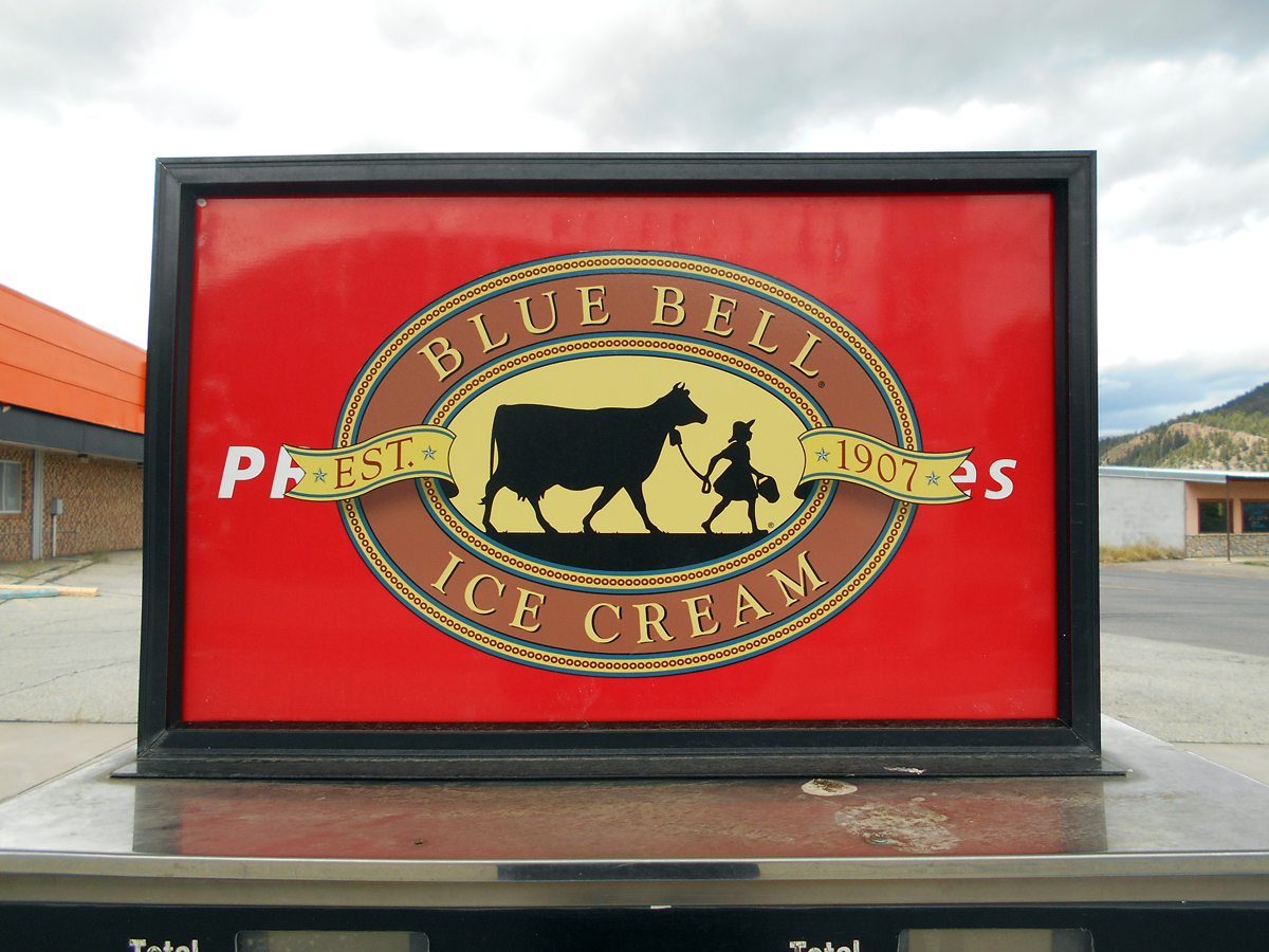
Confused by the Blue Bells Ice Cream ad above the pump... What words are that logo covering up? Why are they being covered? Wouldn't the logo be more effective without hints of words distracting you from it?

The Whistle Pig primary pumps are none too modern.

And not a style you see in service that often anymore.

The concrete pad that held the pumps, was poured in 1993, according to this etching I found. Looking through the Googlemobile's history, I've deducted the gas pumps were removed from Whistle Pig's grave, around the summer of 2017.

Not sure when they left the bright yellow "OPEN" banner, above the Whistle Pig. Seems kinda cruel to do to someone who might be looking for Fuel For Them And Their Ride. Whether that may be the South Fork Liquor or the lazily named "Pizza Time Pizza".

From what I could guess, based on this sign and what the Googles had to offer up, the Whistle Pig closed in September 2015. Roughly a year before these pictures were taken.

Behind the -still there- cash register.
From the looks of things, the former Pizza Time Pizza, would have been toward the back of the building. A small "place order here" sign hangs above the far counter.

Guessing the Pizza Time Pizza kitchen area would have been behind that silver door.

Very hard to see, but there's a small restroom sign near the ceiling, where the wall goes back behind the cooler doors.
To the right of this picture was a separate retail area. The building only had one customer entrance, but a second door inside the main one would take you inside of...

South Fork Liquor!
I wish Pizza Time Pizza had a cool sign...

Inside South Fork Liquor. That Beer Cave is rather tiny, and probably not as far away as it looks. You can even see my reflection in it. I'm even further away, I'm still sort of inside there.

Since it's not Pizza Time anymore, Shane's Grub Wagon has sped onto the scene, to post an advertisement on one of Whistle Pig's pumps. I'm sure their food is just great, but what if they accidentally hired someone that HATES to serve great food. And he stomps around the Grub Wagon, all day, really angry because the Grilled Fajita Skewers are heavenly. And the only way Shane figures this out, is one day he decides to serve some really bad food, and that guy is overjoyed by it. He's absolutely thrilled that the King Ranch Chicken tastes like Moldy Poop with Dead Spiders in it.
Uh yeah... Too much Negativland and chocolate bars for me tonight... I'll finish this tomorrow.
Or in three days.
However, there is some good news...

The Whistle Pig has a new tenant! If it's Time for Pizza, but not Pizza Time, It's now Time for Pizza at Mountain Pizza and Taproom. Looks like they took over the building and opened up in July, 2018. Their photos on the Googles show a great job remodeling the Whistle Pig, and their pizza looks pretty tasty.
A month before they opened in South Fork, they opened a Mountain Pizza and Taproom in Pagosa Springs, Colorado. Coincidentally, that’s where we are going!

So let's get back on highway 160 and get west!
Not like it's pizza time or anything...
After driving west for about a half hour, climbing higher into the mountains as we go, we reach a small pull-off on the side of the road. For the middle of nowhere, there’s ample parking for this natural tourist spot...

The Continental Divide isn’t exactly a tourist trap, but it was a stop we needed to make. Standing at that marker, you’re exactly 10,857 feet above sea level. Which would be the highest I’d be all day.
Back on the road, which goes up a little and down a little, before the next stop.
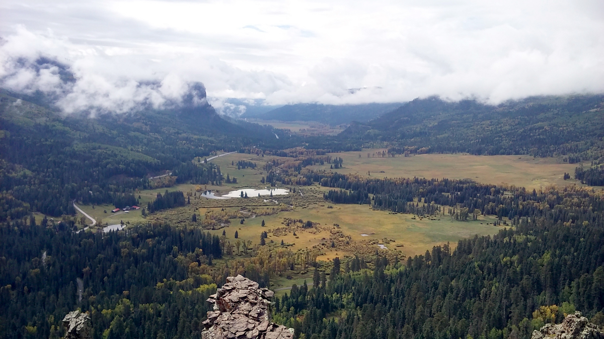
Wolf Creek Pass Scenic Overlook
In just a few short miles, we would travel from the height where I took this picture, all the way down to that tiny 2 lane road on the left side of this picture.
The whole descending drive down the mountain, I couldn’t get this song out of my head.
Well, at least the chorus.

Wolf Creek Pass was pretty treacherous and scary to descend. Half way down I pulled off the road to get my heart rate back to normal, and smoke a cigarette or two. That steep grade was a nail biter, and I needed a break.
We were staying at the High Country Lodge, which was just a few miles west of the base of Wolf Creek Pass. Couldn’t have come soon enough as far as I was concerned. The drive from Denver to Pagosa Springs was pretty smooth overall, but the last 20 miles were too white knuckle for relaxation.

I didn’t care for the pictures I took of the hotel, so we’ll go with this postcard to represent lodging. We just had a standard room for 3 nights, which were pretty basic compared to that beautiful image of the Log Cabin interior. Those circular hot tubs were also very nice, however the temperature was only in the mid-30’s at night. No problem while submerged up to your neck in hot water, but getting out and walking back to the room in wet shorts was pretty damn cold.

Our room had this weird painting of horses with long straight metal hair.
And they’re all named Nelson.

The bears don’t like to be pet.
I can relate.
You know what you don’t want to feed the bears?

Some of this fine Blue Kudu Chocolate, that we picked up at Nature’s Kiss in Englewood, before embarking on this trip. Although, they’d probably be pretty docile as they digested it. (Provided the dosage was correct...) They may even let you pet them!

On our way into town, I had to pull off the highway for this picture of a very rocky San Juan River, as it crossed into Pagosa Springs. Looks almost calendar-worthy!

Had we not booked a room at the High Country Lodge, we could have chosen the First Inn. Doesn't look as nice, but First Inn boasts "420 Friendly" on the sign, along with Hot Tub and Sauna. An appealing combination, to be sure...

The last retail space in the shopping center by the San Juan River was the Malt Shoppe. We ate here one of the nights. It was quick, cheap and the food was pretty good. However, they were out of ice cream. Not that we wanted any, but I found it kind of funny that as we entered the Malt Shoppe, we were warned that we couldn't order malts. Like I said, that wasn't an issue for us, but as we sat there eating, it was pretty funny listening to the whining and complaining that the people who specifically came there for malts became.
My mentality for dealing with the public would have been to tell that that Ice Cream is seasonal.
They just have to come back when the mines reopen.
Our plan for today was to drive down to the Colorado/New Mexico/Arizona/Utah state border. Conveniently placed at the exact same spot! It's about 150 miles west of Pagosa Springs, so the round trip will likely wipe out most of the day, with appropriate stops along the way there and back.

Highway 160 west of Pagosa Springs, not too far from Durango, Colorado. Driving through this part of the state had incredible scenery. Even though it was nearly a three hour drive to Four Corners, there was enough to see that the time flew by. The land had somewhat flattened out out before we hit the town of Cortez. Which seemed to be a fairly large town for this part of the state. Surprised to see there's less than 9,000 people here. Seemed much larger.

Driving by the Start to Finish gas station and liquor store. They appear to have both started and finished, at this point. Doing a Googles drive by today, I saw the pumps were removed by 2018. The building is still looking like this, but it's now a Mexican restaurant.

Cortez was also the home of this glorious M&M Truck Stop. A gas station plus restaurant plus other stuff had been closed since 2001. The whole site was demolished in early 2021. I regret not pulling over for a walk around of the property, although I read access was difficulted due to closed frontage roads.
After passing through Cortez, we still had a few more miles to go before turning off Highway 160 to find Four Corners. Before that turn, we officially drove onto the Ute Mountain Indian Reservation.

Ute Reservation Visitor Center, in a converted gas station. Closed on the day we came through. According to reviews on the Googles, this Visitor Center is almost always closed. But it was still a cool visual, sitting in the middle of what looks like a desolate desert.
Four Corners Monument Park itself is kind of a letdown. The actual connection of right angles is represented in the center of a square. Each side of the square was set back inside each of the four respective states. Theses sides were used as vendor spaces for the type of trinkets and souvenirs that you'd expect to see. Exactly the same stuff in every booth.
What you see here is all you get...

You think you'd welcome visitors, not T-Shirts...

The unwelcomed visitors would each wait their turn for their chance to stand in the circle. Elevated platforms available for photos, and plenty of bench seating available. The problem being there's no shade. You're out under the sun, and while it wasn't overly hot today, if it were this place would be tough to handle. Unless you were a vendor, in charge of welcoming the T-Shirts dropping by.

The actual Four Corners point itself.
Leave it to Arizona to claim the "under God" portion of the slogan.
Colorado went with "Here meet."
Much cooler.
Hmmm... This is really lame...
Maybe if I brought the Tri-Force, a gate to the Underworld would have opened?
Whether or not this is even the correct spot is apparently open for debate. I’ve read the actual geographic meeting spot is about 40 feet away from the monument. Which is technically in Arizona, I think. This would be my first visits to both Arizona and Utah, but only my second visit to New Mexico...
And I didn't even put in the effort to visit Rob... Dood, can you forgive me?

Next time!
The pop-up food stands around the parking lots were all closed today, so there wasn’t any realistic Four Corners dining options for us. Shane needs to trot his Grub Wagon from South Fork pretty soon. I could go for a Chicken Fried Steak dinner plate. Even if it tastes like moldy poop with dead spiders in it...
Shut up and have some chocolate!
Popped the whole Blue Kudu (minus a small chunk Laura ate) in my mouth before I realized what I’d done. Guess the three hour drive back to Pagosa Springs has potential to be interesting...

Laura stole this rock from Four Corners (can you actually steal a rock?) and wrote on it to signify our Civilly Unifyable Anniversary. Spent in four different states at the exact same time. The rock sat on the kitchen counter at our Greenwood Point apartment in Englewood. It's also sitting on our kitchen counter in Crapids. Pretty much since we moved in. Been over five years now... We still haven't fully unpacked.

The entrance to Four Corners is actually in New Mexico, a couple thousand feet from the Colorado state border. This Highway 597 eastbound shot shows the Colorado border, sort of... You can see the "Welcome to Colorado" sign in the middle of the picture. Just below the line of trees, growing along the banks of a different San Juan River.
Hold on, I'll pull over so you can get a better look...

Even to those of us that aren't T-Shirts? Cool!
It was almost 6pm now, and we had a three hour drive back to the Hotel in Pagosa Springs. I wanted to get as far as we could before the sun went down. You want to have maximum visibility in unfamiliar territory. Driving us off a cliff would probably screw up the rest of the night. Stops were going to be kept to a minimum.

Earlier in the day we passed a rather large abandoned gas station that had handmade signs posted about this being a Toxic Waste Site, blaming the State of Colorado for it. The building had all these words spraypainted on it, regarding a toxic waste site. "Got Cancer Yet?" Okay, I'm in! This was the best picture I took of it while we were driving west.
I'm not posting the building with a swastika painted on it.
I wanted to make sure I didn't miss it on the way back, since I knew I couldn't pull over and park. From the context of what the landowner painted on his buildings, I wouldn't dream of going anywhere near it. You fully expect for be shot for crossing those fences. So I had to time my shot just right, as we cruised by at 60mph. Fingers crossed oncoming traffic doesn't block your shot.

Like this stupid truck did, just east of South Fork. There was a beautifully abandoned house, in total disrepair, yet fully visibly from the highway. Centered and focused and ready and... Damat!

Luckily I was able to get this shot, including two of the most prominent signs. Not as clear as I'd liked, but I'll take it. After all, as long as I've got some sort of record of strange stuff like this, I can use it. Would be hard to tell this story without any of my own pictures. When you see something like this, while driving in new areas, it's going to stick with you. So I had to see what the Googles had to offer my story...
The former gas station sits between Mesa Verde National Park (that I would have liked to visit) and the town of Mancos (The Hands of Fate). Decades ago, it was known as the "Wild Wild Rest". There was an RV park, campgrounds and a motorcycle racing track at the site. Races, rodeos and other events were held here, drawing decent crowds for the area. There was a Sinclair Gas station and convenience store operating at the site for years, even after the Wild Wild Rest area closed. In 2004 the gas station closed.
There was an issue when the underground fuel tanks were removed inn 2006, where the landowner claimed thousands of gallons of fuel were spilled into the land. He then puts up all sorts of crazy signs on the property. The agency responsible for the tank removal drilled test wells to check for contamination. After the drilled 30 holes on the property, the landowner refused all access to his property by state officials or anyone associated with the company responsible for the tank removal. In a truly baffling move, he sues the company for trespassing on his land (?!). He asks for $1.7 million dollars in damages. The jury rules in his favor, but only awards him $1.
Now that's just funny!

(Photo from the Googles, politely borrowed from George and Lorri Marshall's travel blog.)
After collecting his one dollar in damages, the landowner continued to refuse access to his property for further testing or clean up of contaminated soil. If that is indeed what is needed to be done. Off-site tests of the groundwater have shown no contamination, and state officials continue to tell the public the site poses little health risk.
I wasn't able to find any further news on the Wild Wild Rest, but Google Drive By's reveal that all of the toxic warning signs have been covered up, and the buildings painted to remove the unproven slander. Hopefully everyone has just moved on with their lives, and there's no further need to alarm innocent civilians just trying to get where 4 states meet at the same place.
Something strongly hints at a money grab here...
Shortly after driving by the toxic waste dump gas station, I started to feel a bit different. Maybe there was something to those warning signs? Nope... It had to be the chocolate.

Highway 160 eastbound outside of Durango, Colorado, on our way back to Pagosa Springs. Right around here when the edibles kicked in. Which wasn't that scary. In fact the drive was nice and smooth, albeit curvy and hilly. Didn't even need to summon my refined Azzip Tuh driving skills. We comfortably floated our Impala chariot, on a ribbon of velvety chocolate dreams, with a hint of orange.

Driving through this particular set of mountains, every so often we'd see plumes of smoke coming up from various clusters of forest. Which I read about in the latest copy of the Pagosa Springs Sun. Simple, routine forestry maintenance going on is all. Every once in a while you gotta light one up for Mother Nature. The state prescribed it!
The next day we got up and ready, then set out to find a local place that sounded worth trying for lunch. My hotel waffle alone wasn't going to cut it for long with the hard day of relaxing we had ahead of us...

We opted for Kips Grill & Cantina, and their mixture of American and Mexican food. Which was really good! So if you're in Pagosa Springs, I recommend Kip's for lunch or dinner. Parking is a tad difficult, but the food was well worth any minor hassle you encounter. Plus they have that sweet mountain lion carved out of a tree stump. So there's that...
The last day we were in town, we spent most of the afternoon at the The Springs. An area where hot mineral water bubbles up to the surface. which is the Springs part of the town name. Not sure where the Pagosa part comes from. Our hotel offered discounts to The Springs, if you bought your tickets at the front desk, they'd charge it to your room. Parts of the lot were closed for construction, so parking wasn't the easiest

Along the sidewalk to the front entrance, several springs are shooting up a foot or two above the surface of the giant piles of mineral deposits underneath them. You can can feel them giving off a good amount of heat, and the smell of sulphur is very strong.

The Springs from outside the Men's locker rooms. Most of the soaking pools would have been to the right of this picture, but you can see a couple of them. Each pool would seat between 8 and 20 people, with a large rectangular swimming pool at the top of the hill. Several areas were off limits to the general public. Reserved instead for guests of the adjacent hotel, that is owned by The Springs. The whole complex of hot spring pools goes down the side of the hill, into the San Juan River.

A map of the resort hangs on the wall, outside the locker rooms. They take temperature readings of the different pools every hour, and list them on the map. A sign outside each of the pools tells you what the last temperature was taken at, as well.
For the first hour or so, we checked the place out and tested the different pools to see what temperature range we liked best. We liked the Boulder and Treasure pools, which were between 98 and 99 degrees. I was able to sit up to my neck for a few minutes, in the Paradise pool. Which was listed at 106 degrees, but I backed out on my attempt at the Columbine pool. Registering at a toasty 111 degrees. My foot handled it for about five seconds before I said nope. The Burg was closed down today, and that is the hottest pool, at 114 degrees. Yeah, it didn't bother me that it was closed...
Most of our time was spent in the Blue Lagoon and Dancing Waters. The large swimming pool sized springs were 96 degrees. Perfectly comfortable water temperature to float on your back and forget about everything.

The San Juan River is part of The Springs, which is fed in this area by all the water bubbling up to the surface. Several seating areas are in the river itself. According to the map on the wall, the river checked in at 62 degrees. I watched several people go from a 100 degree pool, walk down and submerge themselves in the river, then go back into a 100 degree pool. I'm sure it's a shock to the system, and likely has some benefits, I don't know that I'd be wanting to do that...
In the middle of the various springs, there's a large covered tent/hut that serves some food and drinks. Taking a break from the hot water, we ordered some appetizery things and sat at one of the patio tables overlooking the river. We stayed in and around the various pools until after 6pm, before leaving the Springs, and going back to the hotel. On our way back is when we stopped at the Malt Shoppe. To not buy malts.
So how did Captain Honkass like his trip to this series of hot springs?
First, a Tip Of The Cap to The Springs itself. When Laura proposed the idea, I wasn't too sure I'd be into it. Basically is a place where you go and sit in hot water. Now, I love sitting and soaking in a Hot Tub for an hour or so. But is it worth the kind of money we are talking to go to a business that provides a bunch of different hot tubs, at slightly varying temperatures? Is that going to be captivating for an afternoon?
Yes! Yes it absolutely was!
Floating in 100 degree mineral water was an excellent finish to the vacation.
Makes me wish Minnesota had some hot springs...
But also a Wave Of The Finger to the old guy in the men’s locker room, just a few feet away from me. Any special motivation for bending over at the waist, giving me the brown eye and ball sack as I was getting dressed? Locker room etiquette old man! You don’t need to completely drop your towel until you’re covered up by some sort of clothing! Or at least move to the other side of the room when it isn’t crowded.
Thanks dood… Guess I needed to see that?
*******
We checked out of the motel just after 11am, and headed up the easier angle of Wolf Creek Pass. This part of the drive covered stops at the Wolf Creek Pass Scenic Overlook and Continental Divide I mentioned earlier in this story. Coincidentally finding used tampon applicators in the parking areas at both stops. (Hope they're not from the same woman, on the same trip, or she is having one brutal day!) I covered the Overlook and Divide already, so we'll just move on to the Wolf Creek Ranch. Another pit-stop on the way to South Fork

The Wolf Creek Ranch Ski Lodge still goes strong here, but the gas station part of it closed here years earlier.

Always love seeing these great "rolling numbers" pumps in the wild. Early 1970's style I think. I pumped gas from those a few times in my life. Found it almost hypnotizing to watch the dials move at different speeds, as it measure your fuel dispensed, in comparison to the price it was set. Several were found in Frazee and Lake Park, Minnesota on my dream vacation to Fargo, North Dakota!

Poor fella is all naked and exposed!

I'm goin' down to South Fork... Gonna have a myself a time...
Friendly faces... Oh look! An abandoned gas station!

Yes, we are back at the Whistle Pig. This is actually when I took the pictures I showed at the beginning of the story. But there's another few notes on the property I wanted to cover.

Across the street (and parking lot) from the Pig, is a large closed up restaurant known as the Hungry Logger. Unfortunately the building was too large to get any real decent photos. All of the windows were too high off the ground for a look inside, and any on a lower level were covered up on the inside.

The Hungry Logger closed in April 2015, according to quick research. It reopened in 2020, then closed again.

Note on the front doors state it is closed for the season.
Multiple seasons actually...

Looking inside the only unobstructed window...
There's a much smaller wood carving of a lumberjack compared to what is standing out in the parking lot...

Biggin is his name. According to the wooden plaque below his knees.

Which reads: "Hello. My name is Biggin. I am 24 feet tall. And I was carved from a 450 year old Douglas Fir by Ron McDowel in the summer of 1987. Please take my picture, but don't climb on me! Thank you"
At least there was something worth taking pictures of, at the Hungry Logger.

Before I go back over to the car, parked under the Whistle Pig sign, there's one more thing to look at.

Behind the Hungry Logger is a small cluster of vacant in-line retail, last known as the Foothills shops.

Which was the best I could make out on the multiple times painted over sign in front.

I wish now that I would have taken the time to get closer to the Foothills. All of the windows were uncovered, with perhaps some cool stuff left behind. But I was in too big of a hurry...

Hey Laura, instead of taking a picture of me walking away from the Foothills, why didn't you tell me to go back and take the appropriate pictures needed from a setting like this?
Very shoddy work here...

We left South Fork and drove east to Del Norte. I was even able to get a semi-decent shot of the large Elk statue on top of the mountain, looking down on the city limits. Hadn't noticed it on our drive out a few days earlier. After stopping at a functional gas station in town, we set out north. Hoping to make some good time, with the brewing storm clouds overhead. We never caught the storm, but ended up right behind it, going back into Saguache.

Where I found another old gas station. This one looks like it's been converted into someone's home.
At least they left those sweet hockey stick style lights up around the property.

This little brick building sits a few blocks away.

About 15 miles outside of Poncha Springs, we saw the remains of some old mining equipment standing by the side of the road.

Inside the town of Poncha Springs proper, we found another old gas station. (Complete with a pair of those sweet hockey stick style lights, out front where the pumps used to be.) The building was currently being remodeled into the Homestead Cafe. Which would be opening soon, according to the sign. But would already be closed by 2018, according to The Googles.

Both of us were hungry at this point, so we decided to try out the food at A Mimi's Cafe (which is now known as the Hunger Junction), next door to Colorado I Scream & Stuff (great name!).

No apologies needed, we aren't looking for breakfast. Although the sign next to it tickled me. "Fresh, great tasting, non-greasy food!" seems a bit more like a defense than a slogan. Were the future owners of the Homestead Cafe talking shit about A Mimi's food being greasy? So a new clarifying sign had to be made?
Though kudos to A Mimi for giving a job to "Rollback", that floating smiling head that used to work the WalMart TV commercials, back in the mid-1990's. I'm sure with virtually nowhere lowering prices these days, honest work is hard to find for a floating smiley head.
My bacon cheeseburger was pretty good, and not any more greasy than I would have expected. The perfect amount of greasy, one could say. Laura was looking at maps while we ate. Both on paper and on the Googles. At one point, she asks me: "Do you want to go see a ghost town?"
That's not a question. Tell me how to get there and we're going!

Back on Highway 285 north, the Arkansas River cozies up to the side of the highway for a brief stretch. Right around here was a turn off that would go past some houses, then turn into a more narrow road as it wound it's way up between the mountains, for about 20 miles. As I drove, she was filling me in on some of the information about the town's history.

At least the road to get up there was in good driving shape. Rain from the storm that passed through earlier made the dirt road slick in places, but nothing scary.

Just before entering the remains of St. Elmo, you pass the rather large foundation. This used to be the mill, and was set up for loading material on the rail cars that used to run along the road into St. Elmo.

A crude map of St. Elmo is on display in the window of the old Miners Exchange building, which is still standing as it did in the late 1800's. One of many original St. Elmo structures left intact from the town's brief boom period. The map shows what the still standing buildings were used for and where everything in town was.
Reprinted from a St. Elmo mini-biography I found on the Googles: "Founded in 1880, Nearly 2,000 people settled in this town when gold and silver mining started. The mining industry started to decline in the early 1920s, and in 1922, the railroad discontinued service. The town was at its peak in the 1890s, when it included a telegraph office, general store, town hall, five hotels, saloons, dancing halls, a newspaper office, and a school house. Once the mining industry shut down, Saint Elmo drastically declined in population. Few people continued to live in the town. Postal service was discontinued in 1952 after the death of Saint Elmo's postmaster."

The restored Miners Exchange building is now used as the St. Elmo general store. Which now has seasonal hours of operation. Though it was not open today. St. Elmo exists today as a tourist destination. The town is slowly being restored through visitor donations and state grants. You can stay in the restored town hotel for a somewhat reasonable price. Which would be a really cool thing to do, but you'd have to be prepared to not have all of today's amenities

Another St. Elmo historic write-up, in the general store window:
"The search for gold brought many to the area in the 1870's The population grew to over 2,000 at its peak. The most successful gold mining operation was the Mary Murphy - it produced over $60 Million. The DSP&P Railroad tracks came up to St. Elmo (now C.R. 162) and continued to Hancock and thorough the historic Alpine Tunnel."
"St. Elmo was considered a hub town for supplies that were then delivered by wagon via Tincup Pass then onto Aspen. The tracks were abandoned in 1922. It is said that most of St. Elmo residents rode the last train out of town and never returned. The last original residents, Annabelle & Tony Stark, were removed by the state due to their failing health in the late 1950's."

Cluster of original St. Elmo structures.

Two more former businesses, looking in amazing shape for 130 year old wooden buildings.

Looking up into St. Elmo, from the bridge crossing the Chalk Creek.
We wandered around up here for a couple of hours, and it was getting late. Eventually I'm going to write a story about St. Elmo itself, as I shot a ton of pictures up here. By the time we made our way down the mountain and back out to Highway 285, it was nearly dark. I certainly didn't mind our return schedule getting thrown out of whack, for a photo opportunity like this.
The rest of the drive back to Englewood was uneventful, and only one more photo was taken between St. Elmo and home. Taken in a Buena Vista gas station restroom...

Thank you to the good Samaritan who attempted to correct the fancy misspelling.
I had no idea where I couldn't spit my seeds...
Maybe you're supposed to read it with a southern accent?
All in all, an excellent vacation. With an unexpected ending that topped a really fun few days away from our everyday Denver lives. We did get to see new stuff and do something fun and new for both of us. Making it a pretty ideal civilous unionizationally anniversary for both of us!

We even found Colorado's nipple!


Comments
Post a Comment