Appreciation of South Platte River Drive - Denver, Colorado
This piece was put together while I was on vacation. Ten days to live in an area outside our norm. With that in mind, I wanted to spend some of that time working on a different kind of story. This isn't about a particular address or structure that I once frequented. I'm not going to write about baseball cards or abandoned Burger Kings, for the moment. Instead, I'm writing about a body of water and the road next to it, that served as a backdrop for a good part of my daily life for quite a few years of it.

Yeah, I don't think I'll ever stop feeling homesick over my time living in Colorado. Revisiting seemingly insignificant pieces from time to time, scratches that itch when it develops. Good thing I took all those pictures...

Given my location of employment for a majority of those Colorado years, I drove a segment of the South Platte River, nearly every day. This was my chosen route because of the lesser amount of traffic compared to the busier paths to work. Since it is nature instead of freeway, it was a little calm before starting (or after ending) my shifts.

While it holds no real practical meaning in my life, it was sill something that brought a sense of visual comfort to my daily commute, to and from work. When you can look out the car window and see running water, it's more calming than large noise barriers and other traffic.

I'm not interested in writing about the entire river. I don't have that kind of time or energy... That river is long, and has a history far broader than my experience with it. For the sake of this, I'm only interested in covering a small part of the river, which flows north along Platte River Drive. The segment from roughly Florida Avenue, south to Dartmouth Ave, in particular. Both the river and the immediate surrounding area, are what I'm concerned with.
My pictures were all taken between 2013 and 2018, so the specific area I'm focusing on also has a specific time period.

The South Platte River has a problem with pollution. Trash is always floating along the shore, with typical littering from careless drivers and pop-up homeless camps (which have really taken over in the last few years since I've left) scattered along the roadside.

South Platte River Drive begins just south of Mississippi Avenue, where it splits off from Santa Fe Drive, in south Denver.

South Platte River Drive ends in Sheridan, after it goes under the Hampden Avenue bridge. This photo is taken looking north, in 2016. On the left side of the picture, you can see the base for an old bridge support, which was taken out in the 1965 flood.

I will arbitrarily declare the Sheridan Regal Cinemas as the ending point of South Platte River Drive. After it opened in the early aughts, this theater was the closest to where I lived. I saw a few movies here, none of them noteworthy enough to remember any of them by name.

While it "ends" in Sheridan, there's a few blocks of South Platte River Drive, that travel through Englewood. Including from Hampden north to Dartmouth. This roughly at Platt River and Floyd, a couple of blocks north of Hampden, and pretty much where Englewood stopped fixing the road. It's an industrial area, and is in rather poor shape. The pavement is uneven, with large and small potholes interrupting your drive.
It may have been fixed by now...

The area west of the river is mostly light industrial and warehouses. Such as this large Goodwill Outlet World, that I never once visited. Probably should have. Betting there was probably some interesting stuff that hadn't made it's way to the franchises spread out in the Denver metro area.

General Shale Brick occupies a large parcel of land, on the northwest cover of Platte River Drive and Dartmouth Avenue. My typical route to work involved driving Dartmouth west to the river, then turning north.

Driving past the main entrance of General Shale Brick.

Driving past the main entrance of General Shale Brick, in the middle of winter.
When you can't see how dirty the drive is.

Rounding the corner is/was the old Colorado Public Service Electrical Plant.

I was surprised to see that most of this complex has been demolished today. The structure with the four chimneys is one of the last remaining buildings on the property.

This building being the other survivor, according to what I saw on the Googles. Guessing Public Service decided to clear away the outdated equipment and buildings over the last seven years.

Demolition started behind these buildings in 2017, and continued after I left the state. These two remained behind.
I might have a few pictures of that later.

Just north of Public Service is Air Liquide.

They sell Liquid Air.
Or something...

As Platte River Drive approaches Evans, several older light industrial/office buildings line the blocks west of the river. Strubel Fluid would be one of them. Some of the others are/were the Living Arts Centre and Street Dreamz. Which I had pictures of, but didn't feel like using them.

The east side of Platte River Drive, in this area, has a flat gravel parking lot for Grant Frontier Park visitors.

Grant Frontier Park features some bike paths that cross the river via pedestrian bridge.

Assembled by Continental Bridge of Alexandria, MN. That's kind of interesting. Alexandria is a fairly small city in north-central Minnesota. I wouldn't expect to see their work this far away. Apparently they won the bid, even with having to do the job some 800+ miles away from their home base.

Looking north from the pedestrian bridge.
The Evans Avenue bridge can be seen at the top of the photo.
Not long after I took this picture, most of the river bank of the right side of this picture was completely torn up to create an area for people to walk on paths down into the river. You'll see what I'm talking about it a bit, if this doesn't make sense.

The bridge after crossing it.

Grant Frontier Park had some cool stuff on the east side of the river. These pictures were taken on June 7, 2015. Which was before the park had some major renovation work done to it.

Drinking Fountain isn't that cool... But I like how it looked.
Walking on the Grant Frontier Park bike path, east of the river, I found some other pieces of greater interest...

Like an old well!

Stubby log cabin!

And a clearly NOT old, covered wagon...
With no cover!
Hooray!
******
June 7, 2015.
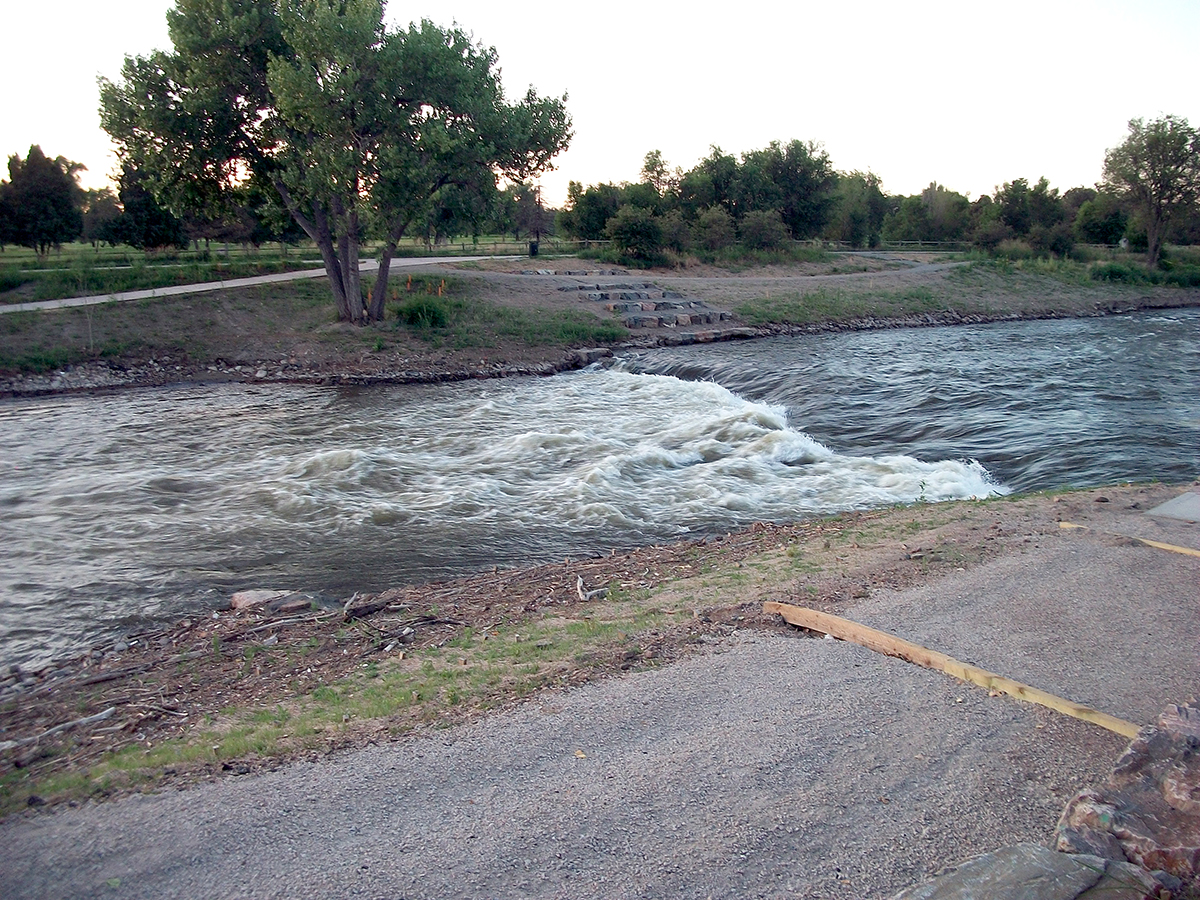
The month of May 2015, was extremely rainy in this part of Colorado. Which made the South Platte River rise above its banks, just as every other river and tributary did. The water had slowly been receding, but was still a ways above where the trails crossed under bridges.

Signs directed you to cross Evans at the intersection. Which I did, after exploring some of the under-bridge area, still above water.

A sign further up warned you of additional bike trails that were closed, for reasons unrelated to current flooding. Love how specific the sign is in declaring how long this project will take. Does that 243 days figure include time lost to the river flooding? Ashamed to admit that I didn't immediately recognize what the "SPRT" on the sign stood for. (South Platte River Trail)

The trail lowers significantly here, to clear the roadway above it. Where it angles down at a steeper rate, is still underwater. High water had been close to where I was standing, just a few weeks earlier.

Flooded Platte River is still well above normal, at the Evans Avenue bridge.

Thought this was a really strange font choice to use on a bridge ID sign...

Stark Naked!

Crossing over Evans, to look at more flooded Platte River. There's something going on in the distance that deserves mention. But I'll get back to it in a few. Let's go down the hill for now.

Looking back at the flooded north side of the bridge.
You can see by the bent blades of grass and weeds, how high the Platte was above them, not too long ago.

And down where it still is...

Yeah sign... That's kind of already happening...
Meanwhile, back up and away from the flooded river banks...

The trail is closed to allow for work on Pasquinel's Landing.

Crews are digging out a portion of the river bank, then will add more trails and natural walking/sitting areas to this part of the park. Since I can't go much further, I'll head back to the Evans bridge.

The future Pasquinel's Landing, looking north from the Evans bridge.
This is similar to the project about to begin, just south of Evans.
I mentioned that already.

The base for a long removed street light, sits on the bridge support.

Looking across the bridge, to the south. Birds were doing it, so I may as well.
Time to get back to the car and move along for now...

America Now!
Which I can see through my windshield, at the southwest corner of Evans and Platte River Drive.
Looking out to the east...

Oh my god! It's suddenly winter outside! What happened?
I better look out my passenger window...

Oh my god! Now it's night time! And it's 117 degrees BELOW zero!

Diamond Auto Body operates on the northwest corner of Evans and Platte River Drive. Notable to me because of the "diamond" shaped awnings, and the wildly inaccurate thermometer inside their sign. I'd driven to work multiple times on a hot summer afternoon, with temperatures in the low 340's. So relieved to get inside an air conditioned office. No matter how stuffy that could get.
The coldest it ever got here was a balmy -439 degrees. I was surprised the sign even registered it. Being that far below Absolute Zero, you wouldn't think the electronics would allow the bulbs to light.
As long as we're on Evans, would should have a little nutrition break.

Before the building was all jazzed up and named Jackie Chan 2, it was a lot less flashy and known as the Twin Eagle. The Twin Eagle closed in early 2014, but reopened a few months later. Now named after the star of Rush Hour 1, 2, and 3.
I'm not a huge fan of Chinese food, but the Twin Eagle had my favorite Mongolian Beef recipe. Almost every other restaurant I've tried has the tendency to make it more sweet than spicy. But the Twin Eagle got it right. As the years wore on, and the Eagle was less and less successful, the food quality went down. We renamed the dinner: "Mongolian Onions", as the ratio had been offset by too much.
Jackie Chan 2's Mongolian Beef recipe was more sweet, with very little spice. (I blame Chris Tucker... For a lot of things...) Slightly fewer onions, which was a bit of a positive. Still, I would be without my favorite Chinese food for another decade plus.

Enter 88 Wok in Andover, MN!
Dialing the calendar back to the weekend after Valentines Day, Laura and I decided to consult the file of take-out menus and coupons that arrive in the mail every week, then pick something we haven't tried for dinner. 88 Wok won the food draft and the chance to audition their Mongolian Beef entree, for my picky tastes.
Well... Sauce appears to be the correct shade of brown... Excellent beef to onion ratio... Oh my god it's Twin Eagle! And now I have my new go-to for Chinese take out!
But if you're not in Andover, and 88 Wok isn't an option, if you're still on west Evans, you should probably just go with...

Tacos Rapidos!
Shown here in April, 2013. When there was still an abandoned Kmart in the parking lot behind it. Kmart had closed a year or so earlier, because no one would shop there. So the building was demolished and a brand new WalMarts put up in its place. Of course the brand new WalMarts was immediately and consistently packed with shoppers.
I'll never understand the evolution of retail over the last two decades.
And it's not about to start making more sense, any time soon...
But I could REALLY go for a Colorado Burrito and a side of Rolled Tacos, right about now!
And that's not going to happen either...
So what's going on at the Platte River?

May 16, 2015
After significant springtime rainfall, the Platte River is again flooding. The water is down a bit from days earlier, but is still significantly higher than normal. On the right, you can see some of the barriers in the river from work a construction crew has been doing on the bank.

May 31, 2015
Additional rain has increased the Platte flooding.

Looking at the Overland Golf Course, across the river.
And you know how we feel about golf courses...

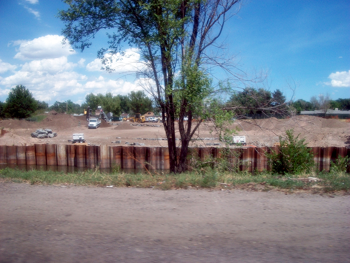
Platte River Drive had been undergoing several years of road work. Which was more to do with the river, than the road next to it. In order to work on the river, construction equipment would often need to interfere with traffic, because there was so little room to work.

For a period of time in 2014 and 2015, a large area along the east side of Platte River Drive, just north of Evans, had a temporary fence put up for construction equipment staging. I don't know how much theft it deterred, but it kept the "campers" from hanging out here.
For a while...

Just north of here, you can turn to go west on Jewell Avenue, and up Ruby Hill. There is a park on the north side of Jewell, with more light industrial and residential, on the south side. Back when I was driving the Blueberry Honkiscle (a 4-cylander 1998 Ford Escort), I hated when another car would turn in front of me to go up the hill first. I needed all the horsepower I could get to make that weak little car climb this grade, and someone else slow climbing in front of me made that even more difficult.
"My car doesn't need a spoiler... It needs a clitoris."
That was my explanation to anyone, in defense of how wimpy that car was to drive. Wonder what 1-877-Kars for Kids did with it? That's K A R S Kars for Kids. I called 1-877-Kars for Kids to donate my Kar today. Well, not today... In May of 2018, I did.
Guess what's stuck in your head, now!

Conversely, driving down Ruby Hill could be a fun adventure. There were a few times the Blueberry Honkiscle caught air, just before the railroad tracks. Though I was more careful in the winter. I wouldn't want to lose control on some ice at the bottom of the hill.

Just in case that were to happen, a concrete barricade was put up at the end of Jewell Avenue, at the bottom of Ruby Hill. Seemed to prevent some cars from overshooting the stop sign at Platte River Drive, then flying straight into the river. Which seemed to happen at least once a year, before these blocks were installed. I remember a few happening in the middle of the night, while I was out smoking at work.
But it doesn't catch all of them...

July 6, 2015
Oh look, there's a car stuck in the Platte River! It came to rest about a block north of Jewell Avenue, but I saw no indication of where it entered the river. You'd expect to see some sort of tire marks going through the vegetation along the river's edge. But there were none in the area. The river isn't all that deep, even when it's flooding, so I can't imagine the car floated all that far before stopping here.

July 18, 2015
About two weeks later, I decided that since the car was still in the river, I should try for some better pictures of it. The car wouldn’t be removed for another week, so it spent at least 3 weeks partially submerged. In the days since I took my first picture of the car, the river has broken the car's sunroof.

How about an artistic shot, with sunflowers and crime scene tape?

A hundred or so feet to the north, a sort of ramp had been built to provide some sort of access to the Platte River.
You can see where the car is in relation.
The Platte River drops off by the ramp.
I don’t think the drop off in the water was as dramatic before recent work done at the river.

During the 2014 work on Platte River Drive, this old shed was demolished and not rebuilt. Never knew its purpose, and I don’t think I ever saw anyone doing anything in it. I also never got a decent picture before it was gone.
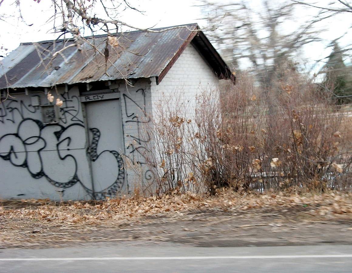
This shot from December, 2013, was about the best I did. Despite it being cut off.
The taggings were always quickly covered up, soon after they'd appear.

The shed is already gone, and work is being done on the river access ramp, in October, 2014.

Same area, photo of the ramp from the opposite side of the Platte River.

Rushing water, north of the drop off in the river.
The Florida Avenue bridge can be seen in the upper right of this picture.

While the height of the water has gone down, the river is still over its banks, flooding several newly planted trees along the shore. Since we’re already on the east side of the Platte, let’s walk up to Florida Avenue and check out our next park on the river.

Now we’re at Overland Pond Park!

Cleverly named after the Overland Pond, just adjacent to the river.

Complete with a small walk-out fishing dock.
I have no idea if the fishing here was worth it, but if you wanted to try…

The south side of the pond had this strange small stage looking space.

With a husband and wife duck team, currently headlining.

Walking away from the Overland Pond, on one the several hiking paths in the area.

Not far from here was a big rock on the side of the path.
With a convenient shelf at the bottom for placement of your...

Virgin Mary Commemorative Candle!

A little further away was this little monument amongst the weeds.
Hmmm… I see words….
ENHANCE!

Snoopy? You didn’t attribute this quote to Charles M. Schultz, the author of the comic strip in question?
Instead choosing the cartoon dog for a life affirming quote?
Strange...

After wandering the pond, I needed to deal with a sudden situation. Luckily, there was a Porta Potty parked at the edge of the Overland Golf Course. A place to urinate is a far more useful function for this land, than a stupid golf course, any day.

A quick look west down Florida Avenue, as I cross over to the north side of the bridge.
I agree, sign... Stop Pay Dro. He sucks.

Much like the trails that go under the Evans bridge, the trail under Florida is closed due to flooding, as well.

Overland Pond Park's newly planted trees are also underwater.

I never noticed there was a small creek that flowed under Platte River Drive, emptying into the river, before today.

Just down the trail from the tributary, a gaggle of geese assembled to watch the water. I'm assuming the three adults were lecturing the youth on the importance of water safety. Of course it was in goose-speak, so I couldn't understand it. For all I know, they were making fun of my shoes or something.
Stupid jerks.

Well, not crossing under here.
Wouldn't want these shoes to get wet...

Alright... Class dismissed... Go home!

Standing on the Florida Ave. bridge, looking north.
The river now into its second month of high water, which is moving incredibly fast.

Crossing over to the south side of the bridge.
You can barely see the car in the river from here.

The flooded trail indicates how much the water has receded from its peak levels.

Still sloshing well above the pavement.

Again, the font chosen for the Florida Avenue sign was a bizarre choice...

Walking down the path bordering the Overland Golf Couse, for a new angle at the car in the river...

Still wish I knew the story behind this...

Oh well, time to walk back to my car, parked in Overland Pond Park's parking lot.
Then take Florida west to Platte River Drive south...

Where it's suddenly 26 months earlier?
Hopefully it's not too early to catch the new work being done on the river bank at Grant Frontier Park.

Along the way, I have to make note of the Boognish tagged on this Platte River drainage tunnel. Think it would be safe to say this Boognish is most likely the work of the same south Denver Ween fan, that painted a Boognish on the soon-to-be-demolished London Motel in Englewood, around the same time.
Excellent work on paintin' the town brown, my friend.
Before crossing Evans to visit Grant Frontier Park, here's a quick shot of the progress at Pasquinel's Landing. It's taking shape, in August 2015, when I took this picture.

October 27, 2017
Parked at Grant Frontier Park and walked to the pedestrian bridge. First snapping a picture of the Platte River, looking south. Because the river flows to the north, much of this water was in Englewood a few hours ago.

Looking to the north from the pedestrian bridge, at the new landing built along the river bank. The water level is pretty low in this photo, and a check of the Googles satellite images show even less water in the river. The part of the river that breaks away to flow under walking paths is overgrown with weeds. It has apparently withstood the annual springtime flooding.

Found an old drain on the west bank of the river that I hadn't seen before.
But there wasn't a whole lot that I was interested in Grant Frontier Park, so I walked back to the pedestrian bridge.

Joining a bird, that was looking at me as I approached.

That bird didn't care one bit as I crossed the bridge. Not flying away despite me getting very close.
Leaving the park to go south on Platt River Drive, I need to check on the power plant, just around the curve in the road.

July 17, 2016
Power plant buildings are all intact. I'd heard nothing about plans to remove them. I was really happy with this picture because it was the only one I was able to get that included the "PUBLIC SERVICE" letters on the outer brick wall.

January 29, 2017
And it's gone! Being as far back from the road as it was, it took me a few days to realize that the buildings were being demolished. There's not much left of the building once branded "PUBLIC SERVICE". Which is a properly somber statement about life today...

Stop! And look at the demolition of Public Service!

Kind of like Gates Rubber Company... But on a much smaller scale.

One more angle of the Public Service demolition, before I go home.
Which would still be Englewood for about 16 more months, from when I took the Public Service demolition photos. After that point it's been Minnesota. Which has worked out fine, I can't complain. But I don't think I'll ever feel as comfortable in Minnesota, as I did in Colorado. I can't explain it. That's just how it is.

All of that reminds me of this goose that I saw on the shores of the Platte River, in May of 2017.
I didn't even notice her as I walked along the river.

Walking by, she stood up and glared at me. Protecting her 3 eggs, laying underneath her in a make-shift rock and stick nest. Not the best of conditions to safeguard your offspring, but it's a close by source of water and food. Which is what you need if you're a goose watching over your eggs.
I thought about that as the looming dread of changing our address was coming. Inevitable even if the end date is currently unknown. Our make-shift rock and stick third floor apartment, was going to change at some point in the near future. And we'd have to trade our failing situation for one that may or may not be better.
Sure, the Platte River is filled with pollution and easy to take for granted, if you don't need it. However, as bad as the Platte River can sometimes smell, it's still the source of life for many animals. Stuck living in a polluted cityscape that isn't the best of environments for them. But they adapt because they have to.
Just like we all have to adapt when life starts to smell like a polluted river. Lay your eggs where you can and hope for the best. There's not a whole lot you can do beyond that. (Although glaring at passersby, with intent to harm, is kind of fun too...) The goose is just trying to survive. Just as we all are.
Which is the overwhelming sentiment that comes to mind as I replay the last ten years in my head.
Just hoping for the best, expecting the worst, knowing that I'm ultimately powerless in the grand scheme of things.
At least I have no eggs to worry about. And no young to take care of.
Just Laura and I, and whatever the world wants to throw at us next.
Hey that building across the street seems kind of familiar...

Think I know someone that used to work here...
He's a fucking dick!
******


Comments
Post a Comment